Unmanned aerial systems
Models
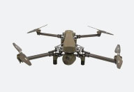
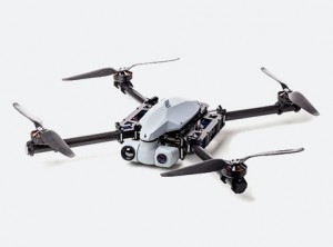
THEIA UAS
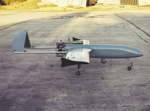
Reliable multifunctional platform meant for operational and tactical information collection with up to 24 hours continuous flight time and 25 kg payload capacity.
THEIA’s standard payload consists of a two-axis stabilised dual-camera gimbal with a daylight camera and an IR-camera for area surveillance or static/dynamic target geo-locating, geo-tracking, video tracking and target acquisition. Its secondary payload contains a high resolution single-axis stabilised photo camera for aerial mapping.
Unmanned aerial system SWAN III
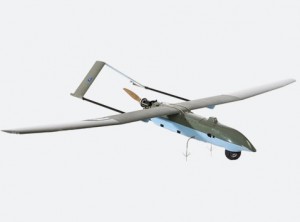
UAS Swan III is the second generation unmanned system developed by ELI Military Simulations. Experience in the field has improved reliability and survivability of the aircraft and enhanced overall usability of the system to produce an easy to use, lightweight, portable and capable platform to suit the needs of any client.
Aircraft is launched by a portable pneumatic catapult.
Swan lands by deploying its parachute and dampens the fall with the aid of an airbag. Parachute is released automatically when reaching the ground.
Ground control station consists of three components: control and video monitor case, antenna tracker case and power module. Antenna tracker is essential to long range communications. All the ground equipment is battery operated—a generator is used for extended operations.
- Range: 50km LOS, 100km LOS (long range version)
- Endurance: 6-8h
- Fuel: Gasoline, 3L
- Speed: 70-160kmh
- Altitude: 100-3000m
- Wing span: 3m
- Weight: 15kg
- Primary payload: Daylight camera with optical zoom & infrared camera + on board recorder
- Secondary payload: Roll stabilized photo camera
- Take-off: Pneumatic catapult (no runway needed)
- Landing: Parachute and airbag
STREAM UAS
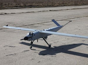
Robust and versatile unmanned aircraft with either automatic take-off and landing or catapult launch and parachute recovery. 10 hours continuous flight time and 6 kg payload capacity.
- modular design,
- large configurable payload bay,
- low noise flight,
- minimum radar footprint.
EOS mini-UAS
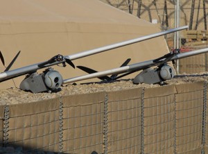
Hand-launched and parachute recovered electrical mini-UAV designed to deliver stable and clear imagery in cost-effective way.
EOS’ wings and stabilisers are inexpensive and field-replaceable, which increases its service life, reduces maintenance costs and makes the UAV suitable for operating in rough environments.
EOS’ standard payload consists of a roll-tilt gyro-stabilised dual camera gimbal with a daylight zoom camera and a fixed lens IR camera that stream live geo-referenced video to a hand-held control station via a digital data link. EOS’ secondary payload contains a roll stabilized geo-referenced photo camera for mapping and surveying purposes.
After the flight geo-referenced images that can be stitched together by means of a photogrammetric software to provide large coverage and high resolution. Users can generate detailed digital elevation models to detect and measure objects on the ground, observe large objects them from different angles and create 3D views.
Multirotor ELIX & ELIX-XL
Multirotor system
The ELIX-XL is a small, man-portable, ruggedized Vertical Take-Off and Landing Unmanned Aerial system designed to capture and transmit high quality digital video.
The ELIX-XL is designed as a complete solution, capable of handling exterior reconnaissance flights. Autonomous capabilities and simple navigation and camera control makes it possible for anyone to fly ELIX- XL with only a few hours of training.
Automatic take-off and landing enables the operator to focus on tasks at hand and enables the unite to be launched without any launch mechanism and land without a landing pad.
With a snap together, tool-less assembly, the system is easy man-portable and capable of rapid deployment.
The ELIX-XL is a modular multicomputer system. Hardware and software are developed and tested by ELI Military Simulations. ELIX-XLsystem offers a wide range of different capabilities like:
- Real time video from two gyro stabilized on-board cameras (Sony and Flir)
- On board video recorder
- Fully autonomous flight control including take-off and landing
- Autonomous mission execution with option to change all parameters during flight
- Ability to select active waypoints and/or change waypoint coordinates and parameters
- Different preprogrammable flight patterns
- Definable actions in case of errors and loss of data link (Return Home, Proceed with Mission, Emergency landing after critical error etc.)
- Multi sensor usage
- Low noise and weak radar footprint
- Controllable navigation lights
The system consists of two main parts – autonomous air vehicle and the human operated ground segment – Ground Control Station. ELIX-XL is a multi-purpose UAV system that can be used in various scenarios, for example:
- border patrol
- reconnaissance/observation
- aerial photography
- geophysical prospecting
- disaster monitoring
- coastguard service
- day/night reconnaissance
- battlefield monitoring
- target positioning
- battlefield damage and casualty assessment
The UAV can be operated in various environmental conditions in a wide temperature range (-20°…+50°C). The system is designed with the latest technology to provide high functionality. With low pricing. ELIX-XL multirotor set is packed into military grade backpack and is carried/ operated by one person.
The ELIX-XL takes off and lands automatically. Operator has to designate a landing area on the map if it differs from take-off point.
ELIX-XL specifications
Due to the flexible concept the exact technical data depends on the individual setup.
Multirotor UAS
 KX-8 Multirotor
Propulsion – 8x BLDC electrical motors
Dimensions – m2m 0.8 m
Weight – MTOW 16 kg (payload capacity 6kg)
Flight time – Up to 60 min
Airspeed – Up to 40 km/h
Standard payload – 2-axis stabilized dual camera gimbal:
• E/O camera with 36x optical zoom (57-1.7 deg FOV)
• I/R camera, 640×470 resolution, 35mm lens (18 deg FOV)
Geo-location, geo-positioning, video tracking.
Data link range (Line of Sight)
Digital data link for video and telemetry 11 km (LOS). The range can be extended with an extra antenna module. Frequency Hopping Spread Spectrum (FHSS) for increased jamming resistance. Encryption: AES256
Autopilot – Threod Systems autopilot, NATO STANAG 4586 compliant protocol.
Automatic take-off and landing, automatic navigation between predefined waypoints, real-time modification of waypoints, loiter modes, scan patterns, emergency contingency routes and landing areas.
Aerial target system
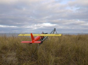
Aerial targets are used in the anti-aircraft weapons training. ELI Military Simulations offers the full service from design, manufacturing, maintenance and training to operation of the targets. Aerial target system consists of a selected number of remotely piloted aircraft, radio controllers, critical spare parts, refuelling accessories and engine starting equipment.
The aerial target set can be transported and stored in a van or passenger car trailer. Airplanes are belly-landed, but they are also equipped with a parachute recovery system, which is used to safely land a target that has been hit or has lost control.
The targets can also be upgraded with a hit detection and counting system, which gives visual information by leaving a smoke trail or by sending the hit count to a ground station via a data modem. The speed of the aerial targets ranges from 100-180 km/h, depending on the engine used.